
- HKH HYCOS
- About
- Bangladesh
- Kurigram
- Sirajganj
- Lalon Shah Bridge
- Bhairab Bazar
- Bhutan
- Korilla
- Sumpa
- Uzorong
- Trashi Yantshe
- Hongtsho
- Gunitsawa
- Panbang
- AWS-Trashi Yantshe
- Gongrichu
- Nepal (Hycos)
- Jiri
- Pachuwarghat
- Mulghat
- Dhankuta
- Busti
- Tumlingtar
- Turkeghat
- Okhaldhunga
- Bahrabise
- Pakistan
- Nowshera
- HS-Gupis
- AWS-Gupis
- HS-Kalam
- AWS-Kalam
- Kailash Sacred Landscape Project
- Jumla
- Humla
- Chainpur
- Chamelia
- Patan Baitadi
- Rara
- GTS
- Dadeldhura
- Surkhet
- Jumla
- Pokhara Airport
- Bhairawa Airport
- Simra Airport
- Kathmandu Airport
- Okhaldhangu
- Biratnagar Airport
- Taplejung
- Dhankuta
- Dhangadi
- Dipayal
- Dang

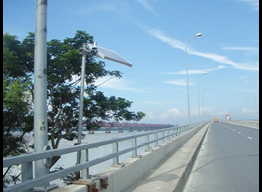
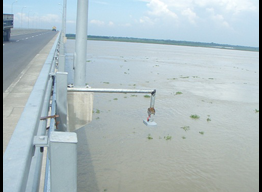
Lalon Shah Bridge
| Address | Between Ishwardi Upazila of Pabna and Bheramara Upazila of Kushita | Station Type | Hydrological and Precipitation Station |
| Latitude | 24° 3'48.64"N |
| Longitude | 89° 1'22.04"E |
| Altitiude | 12m |
| River | Ganga River |
| Accessibility | Road accessible 50m from the proposed station |
| Landmark | Below the western end of the Lalon Shah Bridge |
| Contact Person | NA |
| Sensors Used | Radar Level Sensor and Tipping Bucket |
| Installed On | 9th August 2012 |
Disclaimer :
The data posted is in real-time basis(raw data) which has not been throughly checked & therefore should not be used for scientific purpose
The data posted is in real-time basis(raw data) which has not been throughly checked & therefore should not be used for scientific purpose
